Showing all 4 results

Scarce 20th century Australian artists print and map drawers

As you can see, I’ve used this for my 16th to 19th century unframed engravings over the years,

As closing soon, have no more use.

Drawer sizes vary, divided (x8): W.38cm D.51cm / full length (x5): W.78cm D.51cm

H.89cm  W.90cm  D.69cm


Above: A 19th Century carved French walnut mantle/wall mirror.

Retaining the original, well aged bevelled mirror.

H.115cm  W.108cm

Two hemisphere world maps by Coronelli 1691 – CGW134490-1

THIS ITEM HAS BEEN SOLD

 
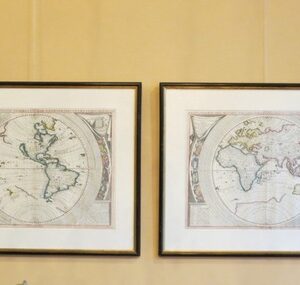
Two hemisphere world maps, copper engravings with original hand colouring. 1691 by Coronelli V.M. Franciscan monk, cosmographer, cartographer, publisher (1650-1718).

‘Planistero del Mondo’.Planisfero del Mondo Nuovo,

Descritto dal P. Coronelli, Cosmografo Publico [in set with] Planisfero del Mondo Vecchio, Descritto dal P. Coronelli, Cosmografo Publico –

World: set of two hemispheres with insular California on the western hemisphere map.

(Italian)

Thevenot, Melchissedec 1663 CGW381533

THIS ITEM HAS BEEN SOLD

 
Stock CGW381533

Thevenot, Melchissedec 1663

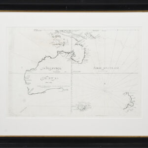
The sixth and final state of the first published large scale map of Australia, showing the track of Tasmans first voyage and Tasmans 1642-43 and 1644 discoveries in Australia and New Zealand.

Note: The map contains dates of particular discoveries however the map was first published in 1663. This edition published in the posthumans ‘Nouvelle Edition’, Paris 1696.

C. 1696

48 cm x 61 cm (unframed)

66 cm x 85 cm (framed)

Pontanus – 1611

THIS ITEM HAS BEEN SOLD

 
Stock AA2006
Johannes Isaacius Pontanus

Map of Africa extending eastwards to include the Middle East, India and China. Shows Terra Incognita extending up towards New Guinea.

Pl 145 from Pontanus’ “Rerum et urbis Amstelodamensium historia”

Includes table illustrating figures in traditional dress.

1611