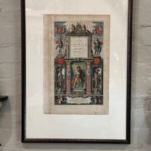
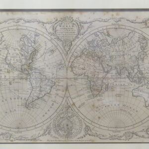
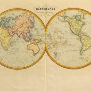
“Le Theatre du Monde, Nouvel Atlas”, Title Pages by Joan Blaeu, Dutch cartographer (1596 – 1673)
“Nouvel Atlas” was a comprehensive world atlas, conceived by Willem Blaeu, but compiled by his son Joan Blaeu, and completed in 1665. The original work consisted of eleven volumes, in Latin, containing 594 maps.
Blaeu was one of the greatest names in early map making. The Blaeu business flourished for over 40 years in the city of Amsterdam. When Willem died in 1638 his sons Johannes and Cornelis took over the business.
Original hand colouring.
Last one remaining, all others in photos have sold.
17th century fish 1680. 1930 oil of Anne Bonney, an 18th century Irish pirate, painted by Raymond Lindsay (son)
One of collection of framed watercolours of birds 1827. Various nudes. Portrait of English gentleman, resembling Captain Cook.
Italian school portrait of a Roman dignitary. One of a collection of Picasso’s, Le Chat. One of many 17th century English maps. Victorian landscape by G Pillig 1940s.
Scottish highlands. A bright Margaret Tarrant. Napoleon hand coloured lithograph. 19th century NZ landscape.
Soldier 1607 – de Gheyn & Soldier 19th century.
Charcoal of a kitten by Mali Moir,
Exceptional Australian artist and close friend.
See more of her works on my website under Contemporary Art also many in Archives.
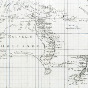
[MAP] Ins Kleine gebrachte Karte von den Sud-Landern zur Historie der Reisen
Ins Kleine gebrachte Karte von den Sud-Landern zur Historie der Reisen Bellin, Jacques Nicholas [Leipzig], 1753.
Copperplate engraving, original folds.
The scarce German version of Bellin’s map of Australia, Carte reduite des terres Australes. The projected eastern coastline joins the charted territories on Van Dieman’s Land and Carpentaria.
First published in Prevost’s L’Histoire Generale des Voyages in the same year, editions in German, Danish and Dutch editions soon followed. Not in Tooley (although cf. Tooley 156/157/157a for French, Dutch and Danish editions); Clancy 6.28.
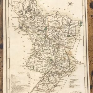
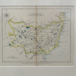
Early 19th Century Map Engraving of Derbyshire 1805
A highly detailed and attractive early 19th Century map of Derbyshire, with fine original hand colour, which was drawn and engraved by G. Cole and J.Roper, respectively, and published in the British Atlas (London: Vernor, Hood & Sharpe, 1807 / 1810).
City of Lichfield, Town of Derby,Borough of Burton and Villiage of Ashton.
A Framed Copper Engraved World Map by Thomas Bowen 1780 “The World including the late discoveries by Captain Cook and other circum navigators. Carefully laid down to the present time by Thomas Bowen”
Framed H. 47 cm Framed W. 65 cm Map H. 29 cm Map W. 48cm
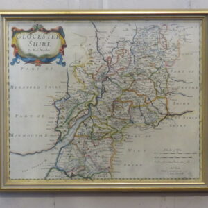
A Framed Map of ‘GLOUCESTER SHIRE By Robert Morden 1695 – 1730 An interesting and attractive framed hand coloured copperplate engraving map of Gloucestershire First published by Robert Morden in 1695, which appeared in Camden’s Britannia (London: Swale, Awnshaw & Churchill, 1695 – 1772) H. 40 cm W. 47 cm
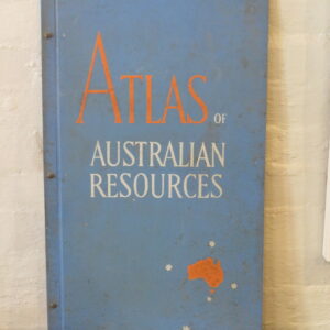
A Very Large Important ‘Atlas of Australian Resources’ Featuring full colour illustrations of mineral deposits, soils, rainfall, temperatures, agriculture, population, forest, railways, drainage and much more.
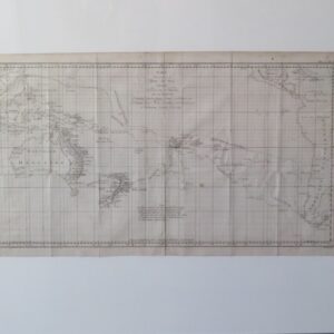
Carte d’une partie de la Mer du Sud Contenant les Découvertes des Vaisseaux de sa Majesté… Paris, Saillant et Nyon & Panckouke, 1774.
Antique chart of the South Pacific showing Australia and New Zealand, engraved by Benard for a French edition of Hawkesworth’s important work ‘An Account of the Voyages for Making Discoveries in the Southern Hemisphere, first published 1773.
The routes of Byron, Wallis and Carteret are shown, as well as Captain James Cook’s first voyage.
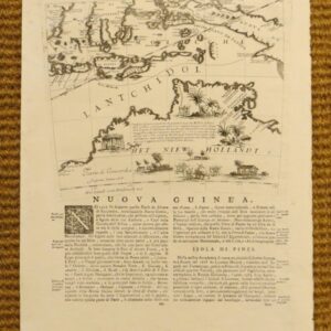
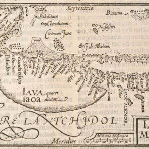
Woodblock on page of text from ‘Iohn Huighen van Linschoten his discours of Voyages into ye Easte & West Indies’, (London 1598).
A map based on Portuguese charts, from the first English edition of van Linschoten’s ‘Itinerario: Voyages ofte schipvaert van Jan Huyghen van Linschoten naer Ooost ofte Portugaels Indien’, 1579-1592 (1596).
Van Linschoten was a Dutchman who had spent a lengthy period in Portuguese service in Goa. In gathering and publishing higherto unknown information and maps relating to the Spice Islands, he enabled the Dutch and English to challenge the Portuguese monopoly in the East Indies. The placenames on the maps in van Linschoten’s work are in Portuguese, and the last section is a brief history of Portugal, suggesting the possiblity that van Linschoten had perhaps obtained a manuscript copy of the Portuguese geographer Barros’ fabled, incomplete and unpublished work, ‘Treatise on Geography’.